
The Vercelli Seamount is the most important structure of a complex SW-NE oriented system of ridges arising from a bottom of about 2000 m in the northern Tyrrhenian Sea. It consists of a granite intrusion episode dated back to 7.2 Ma (Barberi et al., 1978, 1989; Zhuleva, 1988). The Vercelli Seamount owns 20° steep walls (Gallignani, 1973; Zhuleva, 1988). At around 200-250 m water depth, flat terraces, formed during the last episode of low stand of the sea level, are present and are buried below organogenic coarse and medium sand. The walls then start again to be gently sloping (1°-3°) up to about 100 m water depth, where an elongated pinnacle reaches 60 m water depth (Zhuleva, 1988). The pinnacle has an asymmetric shape, with a steeper SW flank (17°) with respect to the NE one (11°) (Gallignani, 1973). The hydrothermal activity of the seamount is responsible for the iron-manganese crusts (up to 2 cm thick) found on the deep granites (Zhuleva, 1988).
The mesoscale oceanography of the Tyrrhenian Sea is characterized by a major cyclonic circulation along its boundary, while in the interior several gyre structures can be observed. The Vercelli Seamount is located within a transitional area between two gyres: cyclonic in the north and anticyclonic in the south (Artale et al., 1994). These gyres are usually considered wind-driven (Nair et al., 1994), but recent investigations have revealed the relevant role played by topography (Budillon et al., 2009; Vetrano et al., 2010). The northern gyre allows the inflow of north-western waters, partially coming from the Algerian-Provencal sub-basin. It is characterized by seasonal variability although it is recognizable all year round. It generates vertical mixing of surface and intermediate waters, leading to a general increase in inorganic nutrient concentrations and the stimulation of primary production in the euphotic zone (Morel and André, 1991; Nair et al., 1994). The southern zone, instead, seems to be mainly characterized by horizontal water movements, generating a convergence zone and leading to strict oligotrophic conditions (Povero et al., 1990; Astraldi and Gasparini, 1994).
Due to its morphology and its position with respect to the main hydrological structures, the Vercelli Seamount exerts its influence on a number of environmental features, although a clear “seamount effect” was not found, due to the complex hydrodynamic features of the area (Misic et al., 2012).
In particular, at the seamount summit, an accumulation of autotrophic biomass and semi-labile organic matter was found, together with a fast turnover of labile organic matter. The heterogeneity of the habitat, the shallowness of the Seamount’s peak, the higher trophic supply and the availability of the organic matter support a very rich mega and macrofaunal community (Bo et al., 2011; Covazzi Harriague et al., 2015). Fluxes of organic matter were observed downstream (NW side), in the surface-subsurface layer as well as with depth along the seamount flank, thus extending the effect of the seamount for at least 25 km far from the summit (Misic et al., 2012). Changes of the organic matter availability to consumption were observed, especially with depth due to the mixing with sedimentary materials, moreover, the organic matter turnover features suggested also an upstream flux around the seamount (Misic et al., 2012). Also temperature and salinity distributions suggest a divergence region in the North and a convergence region in the South of the seamount. These characteristics are confirmed by the corresponding dissolved oxygen and nutrient distributions (MEDATLAS, 2002).
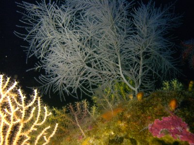
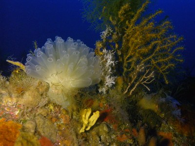
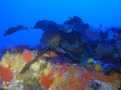
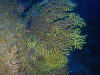
The Vercelli Seamount, an isolated rocky peak penetrating the euphotic zone, plays an important aggregating role, hosting rich coralligenous megabenthic communities as revealed by Remotely Operated Vehicle (ROV) surveys (Bo et al., 2011). The shallowest part of the pinnacle hosts a dense canopy of the kelp Laminaria rodriguezii. The southern side biocoenosis is mainly dominated by the octocorals Paramuricea clavata and Eunicella cavolinii, while the northern side is colonized by active filter-feeding organisms such as sponges with numerous colonies of the ascidian Diazona violacea, and the polychaete Sabella pavonina (Bo et al., 2011). The observed differences between the communities recorded on the two flanks of the pinnacle, both in term of composition and trophic strategy, were put in relation to local current conditions (Bo et al., 2011) and were successively found in accordance with the trophic data (Misic et al., 2012; Covazzi Harriague et al., 2014).
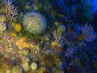
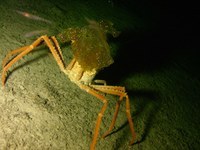
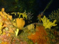
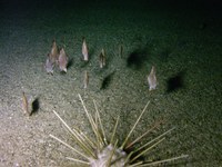
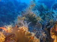
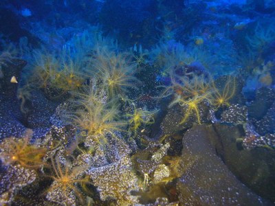
The upwelling hydrodynamic regime suggested for the southern flank explains the greater abundance of passive filter-feeders such as octocorals with respect to the northern flank. On the other hand, the down-welling regime of organic matter on the northern flank and a higher sedimentation level, possibly favoured by a lower inclination of the slope, explain the dominance of active suspension feeders (Bo et al., 2011). The ROV data obtained in the deepest depth range (100-500 m depth) revealed the presence of other interesting deep biocoenoses: on the wide detritic plane surrounding the peak, a continuous belt of the crinoid Leptometra phalangium (with densities of up to 43 specimens m-2) was observed down to 140-150 m depth (Bo et al., 2010). This suspension feeders biocoenosis is clearly supported by the organic material sinking from the euphotic coralligenous community. At 150 m water depth the crinoid facies abruptly stops and is substituted by a detritus-feeding assemblage, mainly composed by cidarid sea urchins. On the edge of the detritic bottom (around 180-200 m depth) a wide belt of dead Dendrophyllia cornigera was recorded, with sparse living colonies. The dead calyxes of this species were frequently covered by the blue sponge Hamacantha (Vomerula) falcula. From 200 to 500m depth, the rocks, covered by a thick black crust of iron-manganese oxide, are characterised by a very poor megabenthic biocoenosis, mainly composed by tubes of serpulids and rare encrusting sponges. A clear decline in the standing crop of the biocoenoses was observed (Bo, pers. observ.). The Vercelli Seamount represents a good model for the benthic zonation of Mediterranean seamounts with summit penetrating in the euphotic zone.
The Vercelli Seamount is not heavily exploited by professional fishing. Nevertheless, some abandoned nets and lines were observed along the ROV track (Bo et al., 2011). Environments characterized by high biodiversity should be worthy of protection by international conservation programs as already suggested for others deep diversity oases of the Mediterranean Sea.
The presence of fin whales (Balaenoptera physalus) close to the Vercelli Seamount was checked (Nascetti and Notarbartolo di Sciara, 1996), as well as striped dolphins (Stenella coeruleoalba) (Pavan et al., 2011). A group of 10 sperm whales (Physeter catodon) was observed on the top of the Vercelli Seamounts’ pinnacle during the ROV operations (Bo, pers. comm., 2009) .
Data from the Atlas of the Mediterranean Seamounts (Würtz & Rovere, 2015).